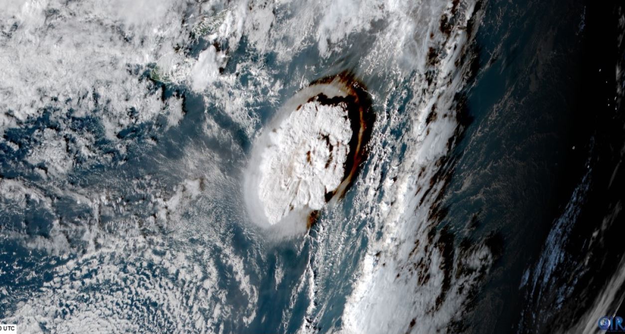
Scientists say they are stunned by what they’ve learnt about the ferocity of the Tonga volcanic eruption in January.
When the underwater mountain blew its top, it sent ash and water-vapour half-way to space, and generated tsunami waves across the globe.
A survey by New Zealand and UK vessels has now fully mapped the area around the Pacific volcano.
It shows the seafloor was scoured and sculpted by violent debris flows out to a distance of over 80km (50 miles).
The mapping exercise at the Hunga-Tonga Hunga-Haʻapai seamount was led by NZ’s National Institute of Water and Atmospheric Research (Niwa).
The gathered data indicates that at least 9.5 cubic km, perhaps as much as 10 cubic km, of material was displaced during the cataclysmic event. This is a volume equivalent to something approaching 4,000 Egyptian pyramids.
Two-thirds of that was the ash and rock ejected out through the volcano’s caldera, or opening.
“You can think of it as ‘a shotgun blast’ straight up into the sky,” said marine geologist and Niwa project director Dr Kevin Mackay. “Some of that material went beyond even the stratosphere into the mesosphere (57km in altitude) – the highest recorded eruption column in human history,” he told BBC News.
The other third was material scraped off the top and the sides of Hunga-Tonga as debris fell back down to sweep out across the ocean bottom.
This transport took the form of pyroclastic density currents, which are avalanches of tumbling, scorching rock and gas. In water, their searing heat would have enveloped them in a frictionless steam cushion on which they could simply run and run at very high speed.
The survey work tracked flows that even managed to travel up and over elevations of several hundred metres.
This explains, for example, the loss of the submarine cable connecting Tonga to the global internet. A large section was cut out of this data link despite lying 50km to the south of Hunga-Tonga and beyond a large hill on the seafloor.
“Where you had these flows, there is nothing living there today. It’s like a desert 70km from the volcano,” Dr Mackay said. “And yet, amazingly, just under the rim of the volcano, in places that avoided these density currents, you do find life. You find sponges. They dodged a bullet.”
The pyroclastic flows also have a part in the tsunami story of Hunga-Tonga.
Waves were recorded across the Pacific but also in other ocean basins – in the Atlantic and even in the Mediterranean Sea.
The Niwa team says there were essentially four ways water was displaced to generate these tsunamis: by the density flows pushing the water out of the way; through the explosive force of the eruption also pushing on the water; as a result of the dramatic collapse of the caldera floor (it’s dropped by 700m); and by pressure waves from the atmospheric blast acting on the sea surface.
At certain phases during the eruption, these mechanisms likely worked in tandem.
A good example is the biggest wave to hit Tonga’s main island, Tongatapu, 65km to the south of Hunga-Tonga. This occurred just over 45 minutes after the first major eruptive blast. A wall of water several metres high washed over the Kanokupolu peninsula, destroying beach resorts in the process.
Niwa natural hazards specialist Dr Emily Lane believes an atmospheric pressure anomaly increased the height of the tsunami waves.
“For the big local waves – in order to understand them correctly, I believe you also have to have this atmospheric coupling,” she explained. “We had a huge pressure anomaly that on its own would have generated a tsunami. So, when you’ve already got waves, then you’re just adding energy to them.”
The Niwa survey, formally called the Tonga Eruption Seabed Mapping Project (TESMaP), was carried out in two parts.
The first stage, which mapped and sampled the seafloor around the volcano, was conducted from New Zealand’s Research Vessel (RV) Tangaroa.
The second stage, directly above the mountain, was given over to the British robot boat USV Maxlimer. Operated by Sea-Kit International from a control room 16,000km away in Tollesbury, UK, this uncrewed vehicle was able to identify ongoing, albeit relatively subdued, volcanic activity. The boat did this by tracing a persistent layer of glassy ash in the caldera back to its source – a new vent cone some 200m under water.
It’s remarkable that only six people died in the January 15 event, and two of those were in Peru. It could have been much worse.
All the results from TESMaP will feed ultimately into hazard mitigation, in preparing Pacific nations sited close to the volcanic zone that runs from New Zealand’s North Island all the way to Samoa. They’ll know better now where to build infrastructure and how to protect it; and, importantly, to appreciate the scale of the risk they face.
“We’ve always underestimated submarine volcanoes,” said Taaniela Kula from Tonga Geological Services. “There are five additional just surrounding Tongatapu. It means we need more planning and urgent planning.” TESMaP was funded by the Nippon Foundation of Japan and organised with the help of Seabed2030, which is an international effort to properly chart Earth’s ocean floor.